Description
Features
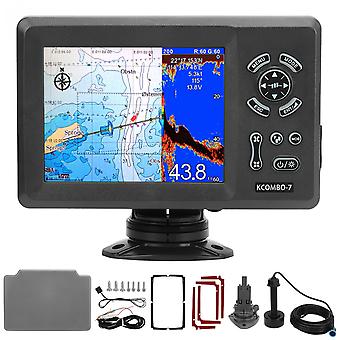
1、7in LCD Display: 7in GPS marine plotter (color LCD 800x600), clear display, easy to read, with IP66 intrusion protection, suitable for harsh marine environments. 2、Compatible Charts: The GPS plotter is compatible with for K‑Chart 2.0, for K‑Chart 3.0, for C‑Map Max and for Navionics +. More convenient for you to use. 3、Built in Fish Finder (Transducer Needed): Using the digital fish swarm detection technology, excellent seabed identification ability, can easily identify fish and fish schools; accurately display the depth of fish schools. 4、Reverb Color: 16 colors (including background color) depending on reverb intensity. Background colors can be selected from blue, light blue, white and black. 5、Dual Frequency Transmit: Support 50 and 200 kHz (different transmit frequencies). Automatically adjust range and gain depending on usage, cruise or fish. 6、Split Screen GPS Plotter: You can adjust the split screen ratio yourself to determine which side is bigger. Save historical location, reverb enters waypoint memory.
Specification
Item Type: Marine Plotter
Material: ABS
Plotter Characteristics:
Waypoints or Icons: 12,000 user waypoints with name, symbol; 10 proximity waypoints
3 System Waypoints: MOB, Start, cursor
Routes: 30 routes waypoint up to 170 points each, plus MOB and Track Navigation or Go to Track modes. Tracks 8,000 points automatic track log; 10 saved tracks (up to 8000 track points each) lets you retrace your path in both directions
Alarms: XTE, Anchor drag, arrival, speed, voltage, proximity waypoint, Timer and AIS (CPA and TCPA) alarm
Drawing: 1000 Drawing Marks; 2000 Drawing Lines (40 points each);1000 Drawing Place Name; 8 colors for Drawing
Pallete: Normal; Daylight exposed to sunlight; Night in dark environment; NOAA paperchart colors
Tides: Built in Worldwide Tide Data
Position Format: Lat Lon
Basemap: Worldwide
External Map: Compatible with for K-Chart 2.0, for K-Chart 3.0, for C-Map Max and for Navionics+
User Data Storage: Internal backup of user settings or external storage card
Plot Interval: 5secs to 60 mins or 0.01 to 10nm
Plotting Scales: 0.001 to 700nm
Perspective View: On off (available for C-Map only)
Celestial: Sunrise, Sunset Moonrise, Moonset
Package List
1 x Marine Plotter (with Base)
1 x Bronze Transducer (3m/9.8ft Wire)
1 x Power Cord
1 x GPS Antenna (10m/32.8ft Line)
1 x Waterproof Cover
1 x Anti Vibration Pad
4 x Double Sided Sticker
2 x Fuse
3 x Long Screws
4 x Short Screw
1 x Instruction Manual
-
Fruugo ID:
278693204-619784808
-
EAN:
9797733645950
Delivery & Returns
Dispatched within 10 days
Shipping from China.
We do our best to ensure that the products that you order are delivered to you in full and according to your specifications. However, should you receive an incomplete order, or items different from the ones you ordered, or there is some other reason why you are not satisfied with the order, you may return the order, or any products included in the order, and receive a full refund for the items. View full return policy